

Dubai Metro Map 2026
You can find out Dubai Metro Map 2026 provided by Dubai Government’s Roads and Transport Authority via the image below:
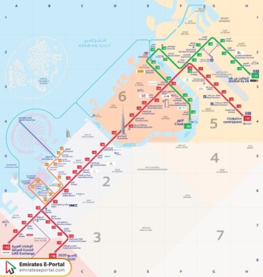
Dubai Metro Lines
By the following table listed below, you can view Dubai Metro lines 2026 and the stations through which the route of each line passes:
| Metro Line | Key Features | The stations through which the line passes |
| Metro Red Line |
|
|
| Metro Green Line |
|
|
| Metro Blue Line |
|
_ |
Read more: Dubai Metro Timing Today
Dubai Metro Map 2026 pdf
Dubai Metro map for the year 2026 can be downloaded in pdf format “from here”, which provides you with knowledge of all the metro lines provided by the Roads and Transport Authority in Dubai, the routes they take, and the stations that each line passes through, in addition to many other details.
Questions & Answers
The number of metro lines in Dubai is three, two ready lines, the green line and the red line, and a third blue line is under construction and will activate in the coming years.
Dubai Metro red line is 52.1 km long and is the longest driverless metro line in the world.
The number of stations expected to pass through Dubai Metro blue line is 7 stations in many residential and commercial areas.
The total area covered by Dubai Metro is seven areas, which include the central areas of Dubai, residential and commercial areas, in addition to the suburbs and peripheral areas.
The fare for transportation via Dubai Metro within one area is 3 dirhams.